Indianapolis Neighborhood Guide: Beyond the Hype
The standard Indianapolis neighborhood guide usually points you toward top schools, historic charm, and polished suburban streets. That advice isn't useless. It is incomplete. It says little about whether you can get to work without a car, whether rent is loosening on one side of town, whether a nightlife corridor sits beside your bedroom, or how crime and noise change from one micro-market to the next.
I'm Jill Hills, and I cover Indianapolis where sex, crime, culture, and local life overlap. My question isn't just where a neighborhood looks good in a listing photo. It's what daily tradeoff are you buying? Indianapolis is a city of distinct pockets, shaped by annexations, transportation corridors, cultural districts, and uneven investment. The right choice depends on whether you're prioritizing walkability, nightlife adjacency, lower housing costs, quieter streets, or a shorter commute.
Rethinking the Standard Indianapolis Neighborhood Guide
Real estate marketing reduces Indianapolis to familiar labels. Broad Ripple means restaurants and nightlife. Meridian-Kessler means established homes. Downtown means culture, while Carmel and Fishers promise schools and newer construction. Those descriptions are useful starting points, but they avoid the harder question: how much daily friction comes with the lifestyle you want?
Indianapolis is strongly car-dependent. AreaVibes' Indianapolis neighborhood data reports that roughly 1.6% of commuters use public transportation, about 81% drive or carpool, and only 4% combine transit, walking, and biking. Read together, those figures describe a city where proximity matters, yet convenient proximity is uneven. A neighborhood may look lively on a map and still leave you driving to work, groceries, or a social district.
That friction also shapes nightlife. A rental near a busy entertainment corridor may offer easy access to bars, clubs, or adult-entertainment venues, while bringing late noise, traffic, and a different sense of privacy. A quieter block farther out may reduce those costs but add time behind the wheel. Neither choice is automatically better.
The city isn't one housing market
Citywide pricing can conceal very different local conditions. A median listing price near $250,000 does not show whether buyers are competing for a small downtown inventory or choosing among more homes on the South Side, according to Realtor.com's Indianapolis market data. Renters face the same split. A walkable core apartment and a cheaper outer-neighborhood unit can differ sharply in space, noise, transportation, and access.
Safety labels deserve equal scrutiny. “Safe” and “unsafe” often describe reputation rather than the conditions on a particular block. ATTOM's Indianapolis neighborhood dataset supports examining housing, transportation noise, transit routes, and historical violent and property crime together. That approach cannot erase risk, but it can expose differences hidden by polished listings or broad neighborhood names.
The practical rule: Choose the Indianapolis neighborhood that fits your commute, budget, risk tolerance, and social life, not an abstract ranking.
Indianapolis is a fragmented city. Transit gaps, rental shifts, nightlife adjacency, and block-level safety can matter as much as architectural appeal.
How Historical Annexations Shaped Modern Indy Streets
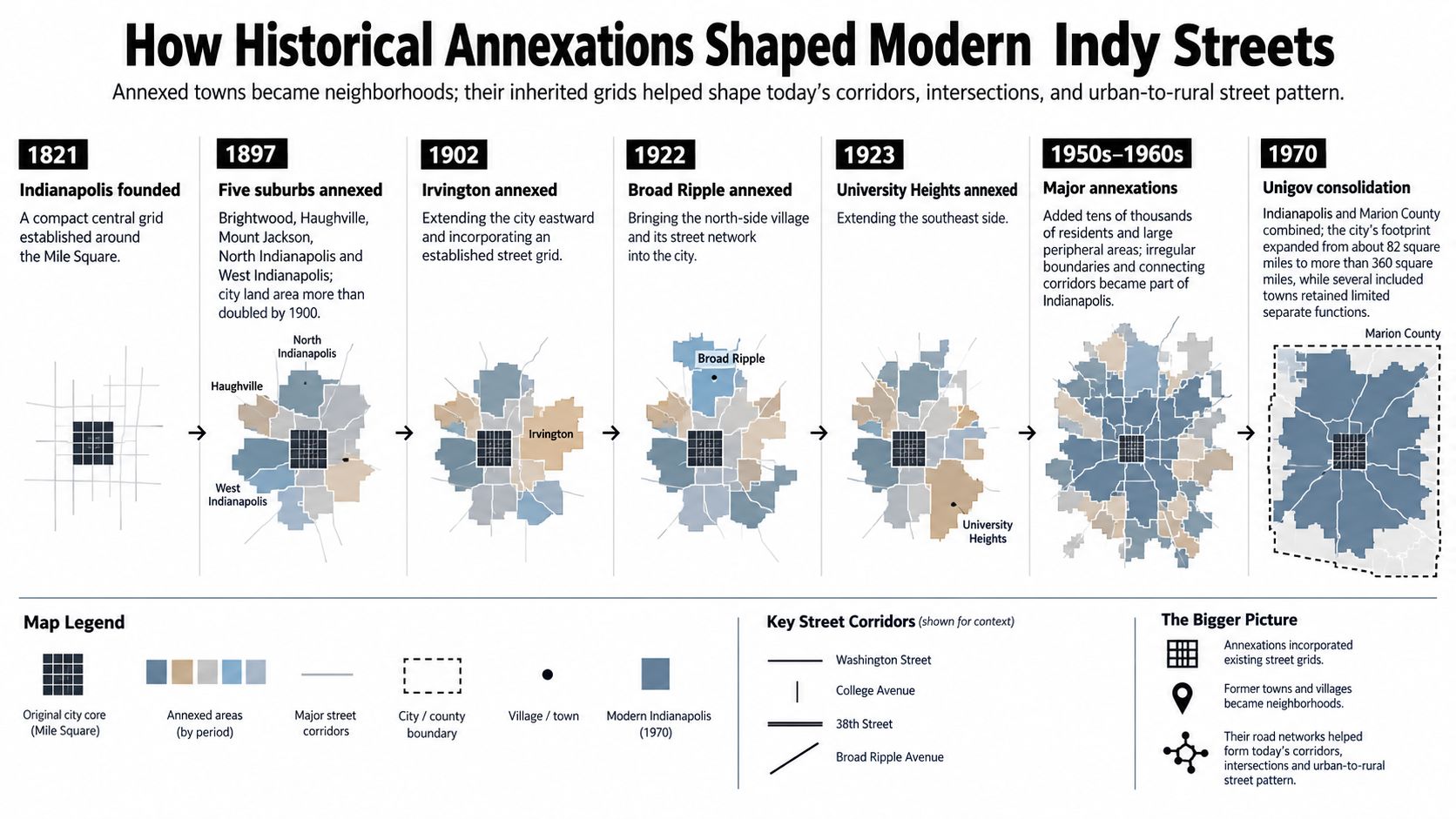
Indianapolis was planned in 1821, yet its modern neighborhoods rarely feel like parts of one uniform city. The first recorded real estate sale took place on October 8, 1821, at Matthias Nowland's tavern near today's Washington and Missouri streets. That transaction established a formal development base downtown, before streetcars, industrial growth, and annexations carried the city outward, according to the Indianapolis Encyclopedia's account of real estate development.
The original city was compact. Later additions brought their own commercial centers, street layouts, and social identities. The result is a city of village-like pockets, uneven sidewalks, arterial roads, and suburban edges that do not always connect easily. For residents, that history can mean a short trip on one side of a boundary and a car-dependent trek on the other.
Growth created a patchwork city
Indianapolis grew from 8,091 residents in 1850 to 169,164 in 1900, a more than 20-fold increase, as industrial activity, housing construction, and transportation links expanded. The history of Indianapolis connects that population growth with districts beyond downtown, streetcar development, and annexation.
In 1897, Indianapolis annexed Brightwood, Haughville, Mount Jackson, North Indianapolis, and West Indianapolis. Irvington became part of the city in 1902, followed by Broad Ripple in 1922. By the end of the 1950s, major annexations had added 28,000 residents, changing the city's boundaries and redistributing its population.
Those changes still shape daily movement. A former streetcar district may offer a tighter grid, older storefronts, and more nearby destinations. A postwar subdivision may rely on arterial roads, larger setbacks, and private vehicles. Neither pattern guarantees lower rent, better safety, or easier access to nightlife and adult-entertainment districts. It does determine how much friction residents face getting to work, transit, errands, or a late-night venue.
Boundaries don't equal lived experience
A neighborhood label cannot show airport or highway noise, the reach of a frequent bus route, vacant homes, or where reported incidents cluster. Those conditions can change within a few blocks, while marketing language often treats a broad area as one experience.
Historic settlement patterns influence street design. Annexation created a larger municipal framework. Transportation history affects whether daily life stays local or requires a car. Cultural identity can also outlast political boundaries, including around nightlife corridors and areas adjacent to adult entertainment.
History provides the map, not a verdict. Anyone comparing Indianapolis neighborhoods should use it to question current conditions, then inspect the specific block, transit connection, traffic exposure, and safety record before choosing a home.
Navigating Housing and Rental Micro-Markets in Indianapolis
A citywide median price can hide the decision that matters most: where inventory is available. Buyers and renters encounter different negotiating power, building conditions, transit demands, and nightlife exposure from one submarket to the next. A broad Indianapolis average cannot capture those block-level tradeoffs.
Recent market data places the citywide median listing price around $250,000. The Realtor.com Indianapolis market snapshot lists 661 South Side listings, compared with 118 on the Near Westside and 141 downtown. Those figures describe separate search conditions. Downtown buyers may have fewer choices concentrated around higher-demand locations, while the South Side offers more opportunities to compare price, condition, and distance from major roads or entertainment areas.
Submarket | For-Sale Listings | Market Dynamic |
|---|---|---|
South Side | 661 | Broadest listed choice among the cited submarkets |
Near Westside | 118 | More limited inventory |
Downtown | 141 | Compact, location-sensitive market |
Inventory tells a different story than reputation
Rental availability is shifting unevenly as well. The same market coverage places average rents near $1,278 for a one-bedroom and $1,600 for a two-bedroom, yet those averages say little about what a tenant receives beyond the unit itself. One renter may pay for downtown walkability, another for additional space farther out, and another for proximity to a cultural or adult-entertainment-adjacent district with more late-night activity and noise.
Near Southside rental inventory rose 204% month over month, a swing that likely reflects a small starting base as much as a true surge in supply. Near Westside and Downtown also recorded strong gains in rental availability. More listings can give renters room to compare concessions, parking, lease terms, and building condition, but the change alone does not prove that rents will fall.
For renters: Treat a sudden availability increase as a reason to compare concessions, lease terms, parking, noise, and building condition, not as proof that every unit is suddenly affordable.
The Far East Side presents a different signal. Its for-sale listings jumped 68.91% year over year, according to a market review covering Indianapolis neighborhood trends. That movement does not resolve questions about commute distance, road access, or infrastructure. It does challenge the habit of focusing only on familiar premium neighborhoods, especially when shifting supply changes the terms available to buyers.
Cost has to include lifestyle
Rent or mortgage payments are only part of the calculation. Parking, fuel, maintenance, travel time, and the cost of reaching work, errands, nightlife, or adult-entertainment districts can change the value of a home. A lower monthly payment may lose its advantage when routine trips require long drives.
Inventory also changes how people search. Buyers may have more room to inspect condition and negotiate. Renters may be able to compare lease language instead of accepting the first workable unit. The useful measure is cost to lifestyle, including safety conditions and the friction of getting where you need to go.
For a downtown apartment, building-specific research matters. A resource such as Park 16 Apartments Indianapolis can help clarify the property context before comparing downtown convenience with the space, parking, and transportation demands of an outer neighborhood.
Solving the Commute and Walkability Optimization Problem
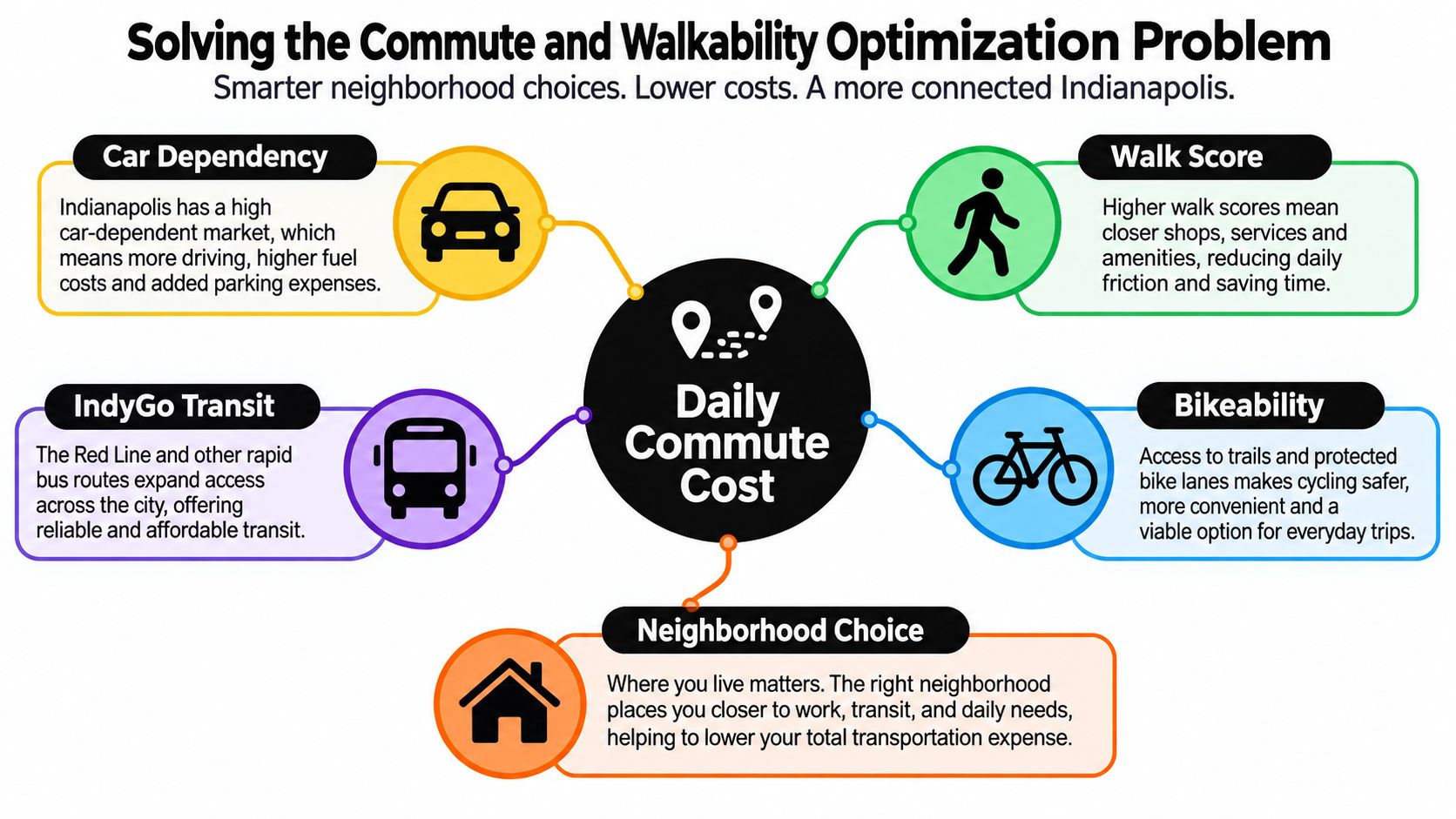
Indianapolis can make a short commute expensive in time, fuel, and patience. Neighborhood choice often requires balancing commute friction, housing cost, and safety. A cheaper home may demand more driving. A walkable address may bring higher housing costs or louder nightlife. A quiet block may sit beyond reliable transit.
Begin with the trip you make most often. Map the route to work, school, family, or regular appointments, then test it at the hours you will travel. A neighborhood that looks close on a map can feel remote when every errand requires a car.
Read scores as infrastructure
Downtown and outer neighborhoods operate from different transportation baselines. Downtown is listed with a Walk Score of 98, Bike Score of 99, and Transit Score of 66. Those figures describe unusually strong access to destinations and transportation options, while areas with sparse coverage and spread-out services impose more dependence on a car.
Transit proximity matters when it reduces last-mile dependence. Check frequent corridors, then confirm that the route serves both your destination and schedule. The IndyGo Red Line may work well for riders near its corridor, while transit access remains uneven across the city.
Screen the block, not just the neighborhood
A neighborhood label can conceal major differences between adjacent blocks. Compare transportation noise, transit routes, and historical violent and property crime at the smallest useful geographic scale. ATTOM's neighborhood dataset can support that layered review, while an in-person visit reveals conditions a database cannot.
Use this sequence:
Estimate the routine. Count repeated trips rather than occasional weekend drives.
Check the corridor. Identify bus access, bike routes, sidewalks, and nearby destinations.
Inspect exposure. Look for highway, airport, rail, or nightlife noise.
Compare total cost. Include parking, fuel, vehicle upkeep, and time lost to driving.
Visit at different hours. A quiet afternoon can conceal a loud evening.
Parks may improve daily quality of life without fixing transportation gaps. Best Parks in Indianapolis can help identify recreation options, but access still depends on whether residents can reach those spaces safely and conveniently.
A score summarizes underlying infrastructure. Its value depends on whether the routes it describes connect to your daily destinations. Walkability serves daily errands, bikeability depends on connected routes, and transit matters when it fits the life you lead.
Exploring Nightlife and Adult-Entertainment Adjacent Districts
Nightlife is not a decorative amenity. It is sound, movement, employment, social connection, and sometimes conflict. In Indianapolis, cultural districts often sit beside homes, apartments, restaurants, venues, and streets whose use changes after dark. A neighborhood guide that lists bars without examining those effects gives residents an incomplete picture.
The city's tourism site identifies Indiana Avenue as a distinct neighborhood and cultural district rooted in Black history. Between the Central Canal and White River, the area connects music, restored neighborhoods, spirituality, and African-American heritage, according to Visit Indy's neighborhood guide. That history complicates a polished nightlife map. The district is a cultural community, not merely an evening destination.

Follow the Cultural Trail
The Indianapolis Cultural Trail runs eight miles through six named cultural districts: Indiana Avenue, White River State Park and the Canal, Mass Ave, Market East, the Wholesale District, and Fountain Square. Life In Indy's Cultural Trail overview describes the trail as a physical connection between destinations often treated as separate scenes.
That connection changes the meaning of proximity. An apartment near one district may provide access to several others, while also receiving event traffic, late-night foot traffic, music, and rideshare activity. Residents who want a short walk to a bar may welcome those conditions. Others may prefer greater distance between their bedroom and amplified sound, crowded sidewalks, or curbside pickups.
Visit the block after dark, not only the district during daylight. Listen for music and traffic, observe lighting and parking pressure, and note how the street feels when venues begin closing.
Adult entertainment belongs in the map
Adult-entertainment venues are part of Indianapolis's commercial and cultural life, even when conventional guides omit them. They can provide jobs, draw nighttime customers, and create spaces for sexuality and performance outside family-oriented neighborhood marketing. They can also raise practical questions about lighting, parking, traffic, safety, and the experience of nearby residents.
Circle City News covers this overlap through local reporting and guides, including three Indianapolis strip clubs worth visiting. Treat a venue list as a starting point. Verify current hours, policies, accessibility, and the surrounding atmosphere in person before making assumptions about a block.
Queer-friendly spaces and independent creators further complicate the division between “residential” and “entertainment” neighborhoods. One district may function as a workplace, social refuge, performance venue, and nightlife destination at the same time. That layered use can carry cultural value, while still requiring honest expectations from anyone considering a nearby home.
Nightlife proximity is a lifestyle decision, not a property feature. Visit after dark, listen from the street, and decide whether the activity feels energizing or intrusive.
Understanding Historic Preservation and Local Policy Limits
Historic charm can hide a regulatory boundary. Indianapolis has 13 local historic districts, 5 conservation districts, and 19 National Register districts, according to the Indianapolis Encyclopedia's overview of historic districts. Those designations do not all impose identical controls, so a neighborhood label alone is not enough. Buyers need to identify the property's specific status before treating an older porch, window, or facade as freely changeable.
The Indianapolis Historic Preservation Commission, established in 1967, oversees local historic districts. In those districts, renovations, new construction, demolition, and site work require a Certificate of Appropriateness before work can proceed. Review may affect exterior materials, additions, fences, windows, replacement systems, and demolition plans.
Charm comes with obligations
Historic designation is a policy framework, not only an aesthetic description. A house may appear privately owned while exterior changes remain subject to review because the district protects an architectural or cultural setting shared by the surrounding block.
Preservation does not freeze every property in place. It does require owners to understand the process before signing a contract or setting a renovation budget. Anyone planning a major addition, replacement windows, new exterior systems, or demolition should ask whether approval is required and whether district standards allow the proposed work.
The rules also matter for neighborhood change. Preserved buildings can maintain architectural continuity and local identity, while review requirements may slow redevelopment or limit how quickly owners respond to damage. In areas where rents, nightlife, and commercial uses are shifting, that tension can shape which buildings change and which remain recognizable.
Renters experience the consequences without filing applications themselves. Older layouts, protected exteriors, restricted alterations, and landlord-controlled maintenance can affect comfort, repairs, and the practical appeal of a unit.
Research before you fall for the porch
Ask direct questions before committing:
Confirm the designation. Check whether the property sits in a local historic district, conservation district, or National Register district.
Identify the reviewing body. Local historic districts involve the Indianapolis Historic Preservation Commission.
Separate ownership from control. Buying a property does not make every exterior change unrestricted.
Price the process. Approval timelines, professional drawings, compatible materials, and revisions may alter a renovation budget.
Inspect the current condition. Historic character does not replace a roof inspection, systems review, or realistic maintenance plan.
Preservation can protect neighborhood identity, but it can also narrow a buyer's options and complicate urgent work. The honest Indianapolis neighborhood guide treats charm as a decision with costs, permissions, and long-term obligations.
Finalizing Your Neighborhood Choice with Hard Data
A neighborhood can look ideal on paper and still fail your daily routine. Rank your priorities first, then compare each area against the same criteria. Attractive photos, school marketing, and a polished reputation should not outweigh the commute, rent, noise, or safety conditions you will actually experience.
A 2016 Indianapolis neighborhoods report from LISC and the Center for Community Progress established five durable indicators: median house value, median household income, the percentage of adults aged 25 and over with a BA/BS or higher degree, the percentage of the population in poverty, and the percentage of housing units vacant, according to the report from LISC and the Center for Community Progress. The report is dated, so use those measures as context alongside current rental conditions, housing listings, transit performance, and incident data.
Match evidence to your household
A transit-dependent renter should check corridor access, walking conditions, service reliability, and available units. A buyer planning renovations should confirm preservation limits before committing to a historic property. Someone drawn to nightlife should visit after dark and weigh adult-entertainment adjacency, late-night noise, parking pressure, and street activity against the convenience of walking home.
Safety data belongs in the comparison, not in a moral judgment about residents. Housing values and income describe market conditions, while education, poverty, and vacancy can reveal different forms of neighborhood change. None of those measures can establish whether a block feels welcoming, culturally meaningful, or compatible with your identity. Firsthand observation still matters.
Use five final checks:
Can you afford the full routine? Count housing, transportation, parking, and likely convenience costs.
Can you tolerate the activity? Visit during the hours you will be home.
Does mobility work? Test transit, biking, walking, and parking.
Do the indicators align? Compare market, vacancy, income, education, poverty, noise, transit, and crime information.
Does the block hold up? Walk it, drive it, and return before deciding.
An Indianapolis neighborhood guide should sharpen your questions rather than name a winner. Circle City News™ covers neighborhood life, crime, sex, culture, and the adult-entertainment industry through Circle City News™. Use the reporting, inspect the block, and choose the tradeoffs you can live with.

Comments